[Back to the main US 395 page]

US 395 history

This is a brief historical timeline over major events in the formation of US 395 and is not designed to be exhaustive.

Return to the main US 395 page

1895
California Bureau of Highways Commission meets for the first time (just two men). After a massive year-and-a-half exploration of the current California transportation system, they recommend a 14,000-mile network of state roads to the legislature. The first route so purchased is the Lake Tahoe Wagon Toll Road, now part of US 50.

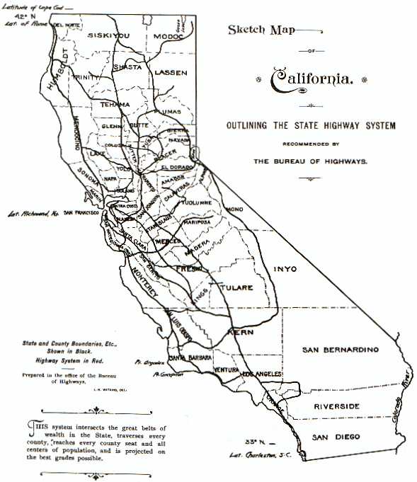
Part of their recommendations includes a route passing through Inyo and Mono counties, skirting the Nevada state line. This was the first part of future US 395 so designated as government highway in all three states, shown on Dan Faigin's 1896 map. The Legislature will convert the Bureau into the Department of Highways in 1897, the body that would later become the California Department of Transportation, or Caltrans.

1905
Washington State Department of Highways (WSDOH, later Washington State Department of Transportation) is first established. Local state roads are gradually allocated and declared over the next decade and a half; future US 395 would eventually occupy (from south to north) State Road 11 "Central Washington Highway," State Road 2 "Sunset Highway" and State Road 3 "Inland Empire Highway."
1909
The California legislature provides $18 million for construction of the State Highway System. This was the basis of the Legislative Route Number system and the first large expansion of California state roads. Gaps in funding required several bond issues and a new gasoline tax to make up the difference. As part of this first action, the oldest portions of the US 395 routing are established as state road, or what is now I-215 between Riverside and Moreno Valley (LRN 19), and what is now US 395 from Inyokern to the CA 89 junction south of the Nevada state line (LRN 23). Additional pieces were added with subsequent legislative acts.
1913
The Oregon State Highway Department is formed, the forerunner of the Oregon Department of Transportation (ODOT). The first highway plan is approved in 1914 and gradually expanded over the next decade. US 395 would be routed on a patchwork of these highways, including OH #2, OH #36, OH #67, OH #28, OH #5, OH #48, OH #7, OH #49, and OH #19. (OH = Oregon Highway; OR = Oregon [State] Route)
1913
The Lincoln Highway, the first continuous coast-to-coast highway, is formally designated and established. Most of it is modern US 50 and US 30. A more detailed routing is in Part 11.
1917
Nevada Department of Highways is established, the forerunner of the modern Nevada Department of Transportation (NDOT). A survey and designation of state roads is established that same year. Part of what will become US 395 is subsequently established as NV 9 and NV 3.
1920 (ca.)
The Midland Trail established in California's eastern Sierra to connect to the Lincoln Highway. Routed partially over LRN 23 (and others), this would become US 6, and is now partially US 395.
1923
WSDOH declares first numbering system. US 395's future routing becomes WA 11, WA 2 and WA 3.
1925
Passage of the Federal Highway Act of 1925, the linchpin of the United States' first interstate road network.
1926
[US 395, 1926.] The establishment of the Federal Highway System, or the US highway system, by the American Association of State Highway Officials (AASHO, now AASHTO) and the federal Bureau of Public Roads, now the Federal Highway Adminstration (FHWA). As part of this action, US Highway 395 is declared as a United States Numbered Highway. Its original routing only extended from Spokane, WA to the Canadian border. It is designated as one of three US 95 spurs due to its proximity to US 195, then the longest of the three spurs. This routing takes over WA 3 north of Spokane.
1928
First signage of California US routes, including US 66, over which US 395 will be carried between Hesperia and San Bernardino, as LRN 31.
1932
The Oregon Highway Division develops a parallel numbering system to avoid conflicts with the new United States Numbered Highway numbers. The Oregon Route System is then overlaid over the extant highway numbers for those routes presently defined (US and state). US 395's future routing exists as OR 15 (later OR 11 from Pendleton south to California) except for OR 54 along OH #7 through Burns (future US 20), OR 31 along OH #19, US 28 (later US 26) along OH #5 in John Day, and US 730 along OH #2 and the Columbia River. Not all Oregon Highways are given an ORS number.
1934
The California Division of Highways establishes the first signage of state routes in California, which does not in general correlate with the LRNs internally maintained. Signage is posted and maintained by the two state Auto Clubs, the Automobile Club of Southern California (ACSC) and the California State Automobile Association (CSAA).
1934
By AASHTO declaration, US 395 is extended to San Diego, California. As part of this action, the new north-south arterial is given WA 2 and WA 11, parts of OH #2 (US 730), OH #36, OH #67, OH #28, OH #5 (US 28), OH #48, OH #7 (OR 54), OH #49, and OH #19 (OR 31), CA LRN 79 and CA LRN 29, NV 9 and NV 3, CA LRN 95 (CA 7), CA LRN 23 (CA 7), CA LRN 145 (CA 95), CA LRN 31 (US 66), CA LRN 43 (CA 18), CA LRN 19 (US 60), CA LRN 78 (CA 740/CA 74) and finally CA LRN 77 (CA 71) to San Diego. Hardly any of it would be signed as such for at least a year.
1935 (ca.)
US 395 is signed in Nevada.
1936-7 (ca.)
US 6 is signed in California. Part of its routing included future US 395 between Bishop and near Inyokern, over the Midland Trail. Signage for US 395 is likely starting to appear in the field.
1937
WSDOH introduces Primary State Highways (digit only) and Secondary State Highways (suffixed) based on 1937 legislation. US 395's routing becomes WA 11 (PSH), WA 2 (PSH) and WA 3 (PSH). US 395 is fully posted south of Spokane by 1938.
1939
US 395 is fully signed all the way to San Diego.
1940
US 10 is shifted south and co-routed with US 395 from Ritzville, WA to Spokane. Its old alignment becomes ALT US 10, and later US 2.
1944
The Federal Aid Highway Act of 1944 is passed, the first major component of the Eisenhower Interstate highway system.
1947
US 395 shifted east to completely bypass Fallbrook and northwestern San Diego county. The remaining alignment is now signed as SDCo S13, SDCo S14 and portions of CA 76, and part of it was CA 78 until the construction of the modern CA 78 freeway.
1947
The first draft of the Interstate highway system is announced, with a total length of 37,700 miles of an authorized 40,000. For US 395's part, this includes the portion in San Bernardino county between San Bernardino and Hesperia that is co-routed with US 91 (to become Interstate 15), and the portion in Washington state between Ritzville and Spokane that is co-routed with US 10 (to become Interstate 90); it also included the new Interstate 80N (later Interstate 84) over US 30, which it would not be routed upon until 1975. Funding would not become available until 1952.
1948
The Cabrillo Parkway (later Cabrillo Freeway) is constructed and opened in San Diego, CA as the US 395 freeway, the first portion of the route to be designated as such. This is now CA 163.
1949
The new Temecula bypass is constructed in Southern California, decommissioning the old narrow Rainbow Canyon alignment. This is now part of I-15.
1952-3
US 395 is significantly realigned in Southern California along a new eastern routing that bypasses Murrieta, Wildomar and Lake Elsinore, along with a minor western shift to a straighter alignment in San Diego. The old route in Riverside county is restored to CA 71. Portions of this new routing are upgraded to expressway and freeway standard over the next several years, much of which becoming part of modern I-215.
1956
The San Bernardino Freeway is completed through to Redlands, CA. This is variously signed as US 60/US 70 and US 70/US 99, and was slated to become Interstate 10 (as it is today).
1956
The Federal Aid Highway Act of 1956 authorizes the expansion of the Interstate network to 41,000 miles and is considered the birthdate of the Interstate highway system. For US 395's part, this adds an additional new Interstate to its future routing, namely Interstate 82 from just over the Oregon state line through south-central Washington to Ellensburg, WA. The alignment that would eventually co-route with US 395, however, was not proposed until the middle 1970s; I-82 was originally considerably further west. Future Interstate 580 in Reno, over which US 395 is routed, may also have been part of this Act.
1959
The Riverside Freeway and Barstow Freeway are opened through Riverside, CA and San Bernardino, CA. US 395 is routed on parts of both, co-signed at various points with US 60, US 66 and US 91.
1961
The Riverside Interchange, the new freeway interchange of US 60, US 91 and US 395, is opened as part of a new US 60/US 395 freeway, the Moreno Valley Freeway.
1964
US 395 north of Carson City, NV is converted to freeway, the first part to be so converted in Nevada. It is followed by the Lakeview-Winters Ranch segment in 1970. It is to be part of the future I-580.
1964
The California Great Renumbering destroys US highways wholesale in that state. Miraculously, US 395 survives fully routed into San Diego and also takes full control of the routing formerly co-signed with US 6 between Bishop and Brown. US 40, US 60, US 66, US 70, US 80, US 91, US 99, US 299, US 399 and US 466 will all disappear from California over the next few years, while US 6, US 50 and US 101 suffer large losses of mileage. Only US 95, US 97, US 199 and US 395 survive intact.
1964-6
Interstate 15 is constructed in stages over the old US 91 alignment north of the Cajon Pass as the Mojave Freeway, including a freeway interchange in Hesperia, CA where US 395 diverges.
1966
The US 395 freeway in San Diego now reaches almost to Escondido, some 20+ miles in length.
1967
Interstate 90 is completed through eastern Washington and US 395 is shifted to the new freeway, obliterating US 10.
1968
The Federal Aid Highway Act of 1968 authorizes the expansion of the Interstate network to 42,500 miles. As part of this action, Caltrans and the Federal Highway Administration extend Interstate 15 along US 395 into San Diego and $201.2 million is earmarked for this large change. By 1969, US 395 would be signed as Temporary I-15.
1969
US 395's official terminus is retracted to Hesperia, CA to the 1964 interchange where I-15 diverges off along the old routing of US 91.
1969
The Mojave Freeway/Interstate 15 is extended south over the Cajon Pass, superseding the old US 395 (and US 66/US 91) expressway.
1970
The Washington Great Renumbering formally dismantles the PSH and SSH system by legislative action in favour of the standard state route system (long since signed ca. 1964), and US 395 becomes legislatively Route 395. Suffixed SSH routes are assigned three-digit numbers based on a parent; US 395's parent number is 39x.
1973
The first portion of Interstate 580/US 395 in Reno, NV finally opens after years of legal wrangling between Panther Valley and Glendale Avenue. It is later expanded in 1980, and is still being extended south as of this writing.
1974
The Interstate 15E project is established as non-chargeable Interstate, using the old US 395 (then I-15, now I-215) routing as the basis for a suffixed Interstate route through Riverside, CA and San Bernardino, CA, and the new I-15 to be routed along CA 71 and unconstructed CA 31 through Corona. I-15E enters the California highway system as Route 194. This legislative gyration saves Caltrans untold millions by making the bypass route federally funded.
1975
I-80N completed through eastern Oregon. Old US 395 through Holdman, OR is renumbered to OR 37 and US 395 routed along I-80N with US 30 to Stanfield, OR, then along old OR 32 to Umatilla, OR where it picks up US 730 to continue along the southern shore of the Columbia River.
1976
The United States Numbered Highway System (the US highways/"Federal highways") celebrates its 50th year. Some dude named Cameron Kaiser is born in Georgia.
1978
The Nevada Great Renumbering alters large numbers of state routes. Most survive, but the numbers are all different. US 395 is not changed by this legislative action.
1980
I-80N is formally renamed to I-84.
1982
I-15E becomes Interstate 215, but only the northermost half that was already freeway standard. The remainder is variously signed as CA 215 and TO I-215. CA 215 shields persist into the early 2000s. Upgrades of the remaining section continue through the latter half of the decade.
1986
I-15 in northern San Diego and Riverside counties is completed and the TEMP I-15 designation on Old Highway 395 ceases to exist. The remainder of I-15 between Temecula and Devore would be finished by 1989.
1986-7
I-82 is completed in Oregon and southern Washington state, and US 395 is shifted onto the Interstate between Umatilla, OR and Kennewick, WA, then along a novel alignment and the historic Blue Bridge to meet its old routing in Pasco, WA. The old alignment cosigned with US 730 along the southern end of the Columbia River becomes solely US 730.
1994
I-215 in California becomes entirely Interstate standard (and signed).
2001
Construction of a new Spokane US 395 freeway alignment, the North Spokane Corridor, begins north of the Spokane River. Its chief delay is funding.
2006
The US 395 freeway between northern Carson City and the northern leg of US 50 opens to traffic, to be a part of the southern Interstate 580.
2006
The Eisenhower Interstate highway system celebrates its 50th year.

Back to the top of the page


[Main page] All images, photographs and multimedia, unless otherwise stated, are copyright © 2004-2008 Cameron Kaiser. All rights reserved. All writeups are copyright © 2004-2008 Cameron Kaiser. All rights reserved. Unauthorized copying or duplication without express consent of the copyright holder is strictly prohibited. Please contact the sitemaster to request permission if you wish to use items from this page.

Go back to the main page